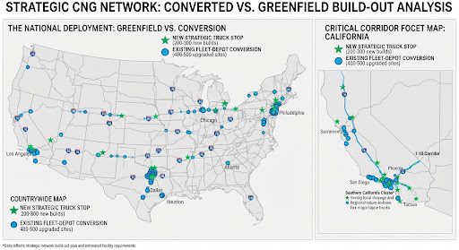
To build a comprehensive, functional cross-country network spanning the major U.S. interstate arteries (east-to-west and north-to-south axes with 250-mile spacing intervals), the total count breaks down into two categories: a minimalist skeleton corridor network versus a fully mature national grid.
1. The Minimalist Transcontinental Skeleton (Corridor-Only Approach)
If the goal is restricted strictly to establishing basic cross-country connectivity along major primary freight spines (such as I-10, I-20, I-40, I-70, I-80, and major north-south connectors like I-35 and I-95):
- Estimated Stations Required: 250 to 350 stations total.
- Math: Covering the roughly 30,000+ miles of primary interstates at a 250-mile maximum spacing threshold requires a string of spaced nodes. However, because many primary interstates intersect and share overlap zones, a lean network can bridge coast-to-coast and border-to-border with a few hundred strategically placed public fast-fill truck stops.
2. A Fully Realized National Logistics Grid (Comprehensive Approach)
To genuinely support seamless commercial trucking operations—meaning trucks are never more than 125 miles away from a fueling point regardless of what regional or secondary freight lane they detour onto—the math scales up significantly:
- Estimated Stations Required: 1,200 to 1,500 stations nationwide.
- Current Baseline: For context, the existing U.S. natural gas infrastructure already sits at roughly 1,385 active CNG stations (public and private fleet-depot combined). However, these are heavily clustered in regional pockets (such as California, Texas, Oklahoma, and the industrial Northeast) rather than configured as an evenly spaced transcontinental highway grid.
Summary Reality Check
Building a complete national network does not require constructing 1,500 brand-new stations from scratch. Instead, it requires upgrading and converting roughly 400 to 500 existing private or regional fleet-depot stations into public-access fast-fill corridors, alongside building 200 to 300 greenfield high-capacity truck stops to close critical geographic gaps in remote sectors of the West and Midwest.
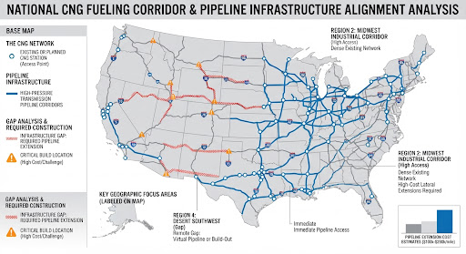
To evaluate where high-pressure natural gas transmission lines intersect with proposed cross-country highway networks—and where new infrastructure extensions must be built—we can map the physical alignment of major U.S. pipeline corridors against the transportation grid.
1. Optimal Access Points (Where Pipelines Parallel Interstates)
Building a fast-fill CNG station is dramatically cheaper and faster when it is placed directly adjacent to an existing high-pressure interstate transmission pipeline (operated by companies like Kinder Morgan, TC Energy, Williams/Transco, or Enbridge).
- The Texas Triangle & Gulf Coast (I-10 / I-20): This is the densest high-pressure natural gas network in the world. Interstate 10 from Houston through New Orleans and across to Jacksonville runs parallel to or directly crosses major trunk lines (such as Tennessee Gas Pipeline, Gulf South, and Transco). Tap costs are minimized here because capacity and pressure are exceptionally high.
- The Midwest Industrial Corridor (I-80 / I-70 through Ohio, Indiana, and Illinois): This region features an intricate matrix of transmission lines (such as ANR Pipeline, Panhandle Eastern, and Rockies Express). Stations positioned near major hub interchanges around Chicago, St. Louis, and Indianapolis have immediate access to high-volume commercial feeds.
- The California Intrastate Corridors (I-5 / I-10): Heavily supported by PG&E and SoCalGas high-pressure transmission lines feeding major logistics arteries out of the ports of Los Angeles and Long Beach.
2. Infrastructure Gaps & Required Pipeline Extensions
Not all parts of a national highway grid have convenient pipeline access. Bridging the gap requires targeted capital allocation for off-grid extensions or virtual pipelines in specific sectors:
- The Intermountain West & High Plains (I-70 through Utah and Colorado; I-80 through Wyoming and Nebraska):
- The Challenge: While major lines like Kern River and Colorado Interstate Gas (CIG) traverse parts of this region, they often cut across rugged terrain miles away from the actual interstate right-of-way.
- The Solution: Building lateral extension lines (ranging from 5 to 25 miles) from transmission mains to highway-adjacent truck stops requires specialized right-of-way permitting and capital expenditure averaging $100,000 to $250,000+ per mile.
- The Desert Southwest Segments (I-10 across West Texas and New Mexico):
- The Challenge: Long, remote stretches between population centers where gas transmission lines exist underground, but intermediate pressure drops or local distribution company (LDC) infrastructure cannot support the massive continuous draw of a high-speed Class 8 truck fast-fill facility.
- The Solution: Upgrading tap stations with dedicated booster compressors or utilizing Virtual Pipelines—where CNG is trucked in mobile trailers from nearby production basins to bootstrap a station until permanent pipeline capacity can be justified by traffic volume.
 Houston TX 77063
 lhgrubbs@ssserv.com
 409-356-4588